
Make a donation
Basin Creek topographic map
Click on the map to display elevation.
Make a donation
About this map
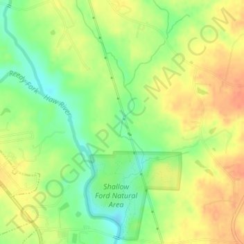
Name: Basin Creek topographic map, elevation, terrain.
Average elevation: 195 m
Minimum elevation: 171 m
Maximum elevation: 215 m
Make a donation
Other topographic maps
Click on a map to view its topography, its elevation and its terrain.
Make a donation
Lakeside
United States > North Carolina > Alamance County > Burlington > Lakeside
Average elevation: 190 m
Granite Village
United States > North Carolina > Alamance County > Haw River > Granite Village
Average elevation: 174 m
Cooper Estates
United States > North Carolina > Alamance County > Graham > Cooper Estates
Average elevation: 167 m
Brookwood Subdivision
United States > North Carolina > Alamance County > Burlington > Brookwood Subdivision
Average elevation: 198 m
Make a donation
Pinewood Forest
United States > North Carolina > Alamance County > Burlington
Average elevation: 192 m
Beverly Hills
United States > North Carolina > Alamance County > Burlington > Beverly Hills
Average elevation: 185 m
Make a donation