
Otematata topographic map
Interactive map
Click on the map to display elevation.
About this map
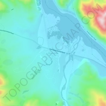
Name: Otematata topographic map, elevation, terrain.
Location: Otematata, Waitaki District, Canterbury, New Zealand (-44.62481 170.17341 -44.58481 170.21341)
Average elevation: 343 m
Minimum elevation: 268 m
Maximum elevation: 694 m
Other topographic maps
Click on a map to view its topography, its elevation and its terrain.
Lindis Pass
New Zealand > Canterbury > Waitaki District
Lindis Pass, Waitaki District, Canterbury, New Zealand
Average elevation: 1,011 m
Ohau Peak
New Zealand > Canterbury > Waitaki District
Ohau Peak, Waitaki District, Canterbury, New Zealand
Average elevation: 1,553 m
Omarama
New Zealand > Canterbury > Waitaki District
Omarama, Waitaki District, Canterbury, 9412, New Zealand
Average elevation: 460 m
Waitaki River
New Zealand > Canterbury > Waitaki District
Waitaki River, Waitaki District, Canterbury, New Zealand
Average elevation: 178 m
Lake Ruataniwha
New Zealand > Canterbury > Waitaki District
Lake Ruataniwha, Waitaki District, Canterbury, New Zealand
Average elevation: 491 m
Kurow
New Zealand > Canterbury > Waitaki District
Kurow, Waitaki District, Canterbury, 9435, New Zealand
Average elevation: 274 m
Otiake River
New Zealand > Canterbury > Waitaki District
Otiake River, Waitaki District, Canterbury, New Zealand
Average elevation: 226 m