
Make a donation
Tehri-Garhwal topographic map
Click on the map to display elevation.
Make a donation
About this map
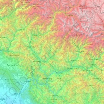
Name: Tehri-Garhwal topographic map, elevation, terrain.
Location: Tehri-Garhwal, Tehri Garhwal, Uttarakhand, 249125, India (29.80000 77.96667 31.20000 79.36667)
Average elevation: 2,339 m
Minimum elevation: 243 m
Maximum elevation: 7,106 m
Make a donation
Other topographic maps
Click on a map to view its topography, its elevation and its terrain.
Haldwani
Haldwani is located at 29°13′N 79°31′E / 29.22°N 79.52°E / 29.22; 79.52, in the Nainital district on the right bank of the Gaula River. Geologically, Haldwani is settled on a piedmont grade (called Bhabhar) where the mountain rivers go underground to re-emerge in the Indo-Gangetic plain. The…
Average elevation: 526 m
Pauri Garhwal
The mountains of Khirsu offer views of the northern Himalayas and attract a large number of tourists. Located 19 kilometres (12 mi) away from Pauri at an altitude of 1,700 metres (5,600 ft), Khirsu is peaceful and free from pollution. There is the nearby ancient temple of Ghandiyal Devta. Accommodation is…
Average elevation: 958 m
Chamoli
The geology of the region shows that the Himalayas are amongst the youngest mountains in the world. During early Mesozoic times the land mass now covered by them was occupied by the great Tethys sea. The probable date of the commencement of the elevation of the Himalayas is about the close of the Mesozoic era,…
Average elevation: 3,712 m
Make a donation