
Haldwani topographic map
Interactive map
Click on the map to display elevation.
Haldwani
Haldwani is located at 29°13′N 79°31′E / 29.22°N 79.52°E / 29.22; 79.52, in the Nainital district on the right bank of the Gaula River. Geologically, Haldwani is settled on a piedmont grade (called Bhabhar) where the mountain rivers go underground to re-emerge in the Indo-Gangetic plain. The Haldwani Bhabhar stretches horizontally, surrounded by the regions of Ramnagar and Tanakpur and lies between the Shivalik hills to the north and the Terai region of Rudrapur to the south. The average land elevation is 424 m (1,391 ft) above sea level. According to the Bureau of Indian Standards, Haldwani falls under seismic zone 4, in a scale of 2 to 5 (in order of increasing vulnerability to earthquakes).
About this map
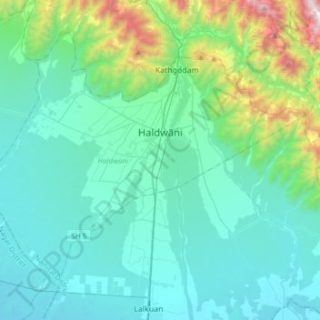
Name: Haldwani topographic map, elevation, terrain.
Location: Haldwani, Nainital District, Uttarakhand, India (29.08483 79.36225 29.29770 79.66641)
Average elevation: 526 m
Minimum elevation: 227 m
Maximum elevation: 2,112 m
Other topographic maps
Click on a map to view its topography, its elevation and its terrain.
Dehradun
India > Uttarakhand > Dehradun
The city of Dehradun mainly lies in Doon Valley and is at a varying height from 410 m (1,350 ft) in Clement Town to above 700 m (2,300 ft) at Malsi which is 15 km (9.3 mi) from the city. However, the average elevation is 450 m (1,480 ft) above sea level. Malsi is the starting point of Lesser Himalayan Range…
Average elevation: 904 m
Mussoorie
India > Uttarakhand > Dehradun
Mussoorie is at an average altitude of 2,005 metres (6,578 ft). To the northeast are the Himalayan snow ranges, and to the south, the Doon Valley and Shiwalik ranges. The second highest point is the original Lal Tibba in Landour, with a height of over 2,275 m (7,464 ft). Mussoorie is popularly known as The…
Average elevation: 1,594 m
Rudraprayag
India > Uttarakhand > Rudraprayag
Rudraprayag district is located at 30°17′N 78°59′E / 30.28°N 78.98°E / 30.28; 78.98. It has an average elevation of 895 metres (2,936 feet).
Average elevation: 1,140 m