
Make a donation
Bristol topographic map
Click on the map to display elevation.
Make a donation
Bristol
According to the United States Census Bureau, the town has a total area of 21.9 square miles (56.8 km2), of which 16.8 square miles (43.4 km2) are land and 5.2 square miles (13.4 km2) are water, comprising 23.60% of the town. Bristol is drained by the Pemigewasset River (forming the southeastern boundary of the town), the Smith River (on the town's short southern boundary) and the Newfound River, draining Newfound Lake and most of the center of town. The highest point in town is Bristol Peak, elevation 1,803 feet (550 m) above sea level. Bristol lies fully within the Merrimack River watershed.
Make a donation
About this map
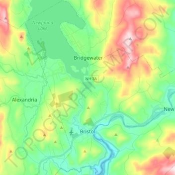
Name: Bristol topographic map, elevation, terrain.
Location: Bristol, Grafton County, New Hampshire, 03222, United States (43.56344 -71.79255 43.67518 -71.65108)
Average elevation: 254 m
Minimum elevation: 95 m
Maximum elevation: 580 m
Make a donation
Other topographic maps
Click on a map to view its topography, its elevation and its terrain.
Make a donation
Stinson Lake
United States > New Hampshire > Grafton County > Rumney > Stinson Lake
Average elevation: 460 m
Make a donation
Make a donation
Make a donation
Campton Lower Village
United States > New Hampshire > Grafton County > Campton
Average elevation: 260 m
Make a donation
Campton Hollow
United States > New Hampshire > Grafton County > Campton > Campton Hollow
Average elevation: 251 m
Make a donation
Make a donation
Corcoran Pond
United States > New Hampshire > Grafton County > Waterville Valley
Average elevation: 522 m
Waterville Valley
United States > New Hampshire > Grafton County > Waterville Valley > Waterville Valley
Average elevation: 567 m
Make a donation
Woodstock
United States > New Hampshire > Grafton County > Woodstock > Woodstock
Average elevation: 333 m
Make a donation