
Make a donation
Montcalm topographic map
Click on the map to display elevation.
Make a donation
About this map
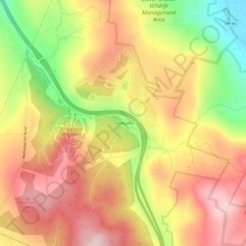
Name: Montcalm topographic map, elevation, terrain.
Average elevation: 436 m
Minimum elevation: 235 m
Maximum elevation: 586 m
Make a donation
Other topographic maps
Click on a map to view its topography, its elevation and its terrain.
Stinson Lake
United States > New Hampshire > Grafton County > Rumney > Stinson Lake
Average elevation: 460 m
Holderness
United States > New Hampshire > Grafton County
According to the United States Census Bureau, the town has a total area of 35.7 square miles (92.5 km2), of which 30.3 square miles (78.6 km2) are land and 5.4 square miles (13.9 km2) are water, comprising 15.05% of the town. Bounded on the northwest by the Pemigewasset River, Holderness is drained by Owl…
Average elevation: 252 m
Make a donation
Dorchester
United States > New Hampshire > Grafton County
According to the United States Census Bureau, the town has a total area of 45.2 square miles (117.1 km2), of which 44.6 square miles (115.5 km2) are land and 0.62 square miles (1.6 km2) are water, comprising 1.34% of the town. It is drained by the north-flowing South Branch Baker River and the south-flowing…
Average elevation: 439 m
Make a donation
Enfield
United States > New Hampshire > Grafton County
According to the United States Census Bureau, the town has a total area of 43.1 square miles (111.6 km2), of which 40.3 sq mi (104.3 km2) is land and 2.9 sq mi (7.4 km2) is water, comprising 6.59% of the town. Enfield is drained by the Mascoma River. Mascoma Lake, in the west, represents Enfield's lowest…
Average elevation: 366 m
Hebron
United States > New Hampshire > Grafton County
Hebron sits at the north end of Newfound Lake, the fourth-largest lake in New Hampshire. The Cockermouth River, the primary feeder to the lake, enters the town from Groton to the west and passes the town center before entering the lake. Hebron lies fully within the Merrimack River watershed. The highest point…
Average elevation: 327 m
Make a donation
Corcoran Pond
United States > New Hampshire > Grafton County > Waterville Valley
Average elevation: 522 m
Make a donation