
Make a donation
Waterville Valley topographic map
Click on the map to display elevation.
Make a donation
About this map
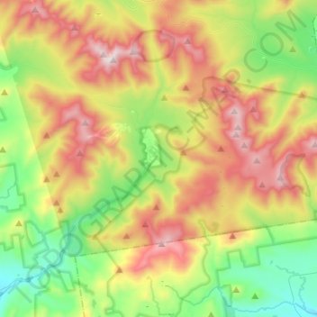
Name: Waterville Valley topographic map, elevation, terrain.
Average elevation: 649 m
Minimum elevation: 205 m
Maximum elevation: 1,307 m
Make a donation
Other topographic maps
Click on a map to view its topography, its elevation and its terrain.
Stinson Lake
United States > New Hampshire > Grafton County > Rumney > Stinson Lake
Average elevation: 460 m
Make a donation
Make a donation
Make a donation
Make a donation
Campton Lower Village
United States > New Hampshire > Grafton County > Campton
Average elevation: 260 m
Make a donation
Make a donation
Campton Hollow
United States > New Hampshire > Grafton County > Campton > Campton Hollow
Average elevation: 251 m
Corcoran Pond
United States > New Hampshire > Grafton County > Waterville Valley
Average elevation: 522 m
Woodstock
United States > New Hampshire > Grafton County > Woodstock > Woodstock
Average elevation: 333 m
Make a donation
Make a donation
Waterville Valley
United States > New Hampshire > Grafton County > Waterville Valley > Waterville Valley
Average elevation: 567 m
Make a donation