
Thank you for supporting this site ❤️
Make a donation
Make a donation
Tasman Bay topographic map
Click on the map to display elevation.
Thank you for supporting this site ❤️
Make a donation
Make a donation
About this map
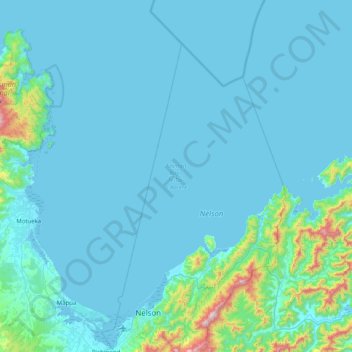
Name: Tasman Bay topographic map, elevation, terrain.
Location: Tasman Bay, Nelson, New Zealand (-41.28788 172.99246 -40.78172 173.79861)
Average elevation: 84 m
Minimum elevation: -1 m
Maximum elevation: 1,194 m
Nelson trails, hiking, mountain biking, running and outdoor activities
Thank you for supporting this site ❤️
Make a donation
Make a donation
Other topographic maps
Click on a map to view its topography, its elevation and its terrain.