
Make a donation
Paravur topographic map
Click on the map to display elevation.
Make a donation
Paravur
Paravur is located at 8.78 N 76 E.[4] It has an average elevation of 10 metres (32 feet). Paravur, 21 kilometers from the Kollam, is a narrow skirt of land stretching in between the backwaters and the sea. There is an elevation of 6 metres above sea level, extending to 16 metres on the inland. Ithikkara river is flowing through paravur. Nedungolam in paravur is now famous for mangrove forest.[citation needed]
Make a donation
About this map
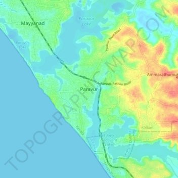
Name: Paravur topographic map, elevation, terrain.
Location: Paravur, Kollam, Kerala, 691301, India (8.76989 76.63153 8.84989 76.71153)
Average elevation: 14 m
Minimum elevation: -5 m
Maximum elevation: 60 m
Make a donation
Other topographic maps
Click on a map to view its topography, its elevation and its terrain.
Ashtamudi Lake
India > Kerala > Kollam > Kottayathukadavu
Ashtamudi Lake (Ashtamudi Kayal), in the Kollam District of the Indian state of Kerala, is the most visited backwater and lake in the state. It possesses a unique wetland ecosystem and a large palm-shaped (also described as octopus-shaped) water body, second only in size to the Vembanad estuary ecosystem of…
Average elevation: 6 m
Make a donation