
Thank you for supporting this site ❤️
Make a donation
Make a donation
Hispaniola topographic map
Click on the map to display elevation.
Thank you for supporting this site ❤️
Make a donation
Make a donation
About this map
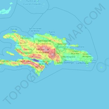
Name: Hispaniola topographic map, elevation, terrain.
Location: Hispaniola, Dominican Republic (17.60422 -74.48093 19.95291 -68.32291)
Average elevation: 69 m
Minimum elevation: -44 m
Maximum elevation: 2,929 m
Thank you for supporting this site ❤️
Make a donation
Make a donation
Other topographic maps
Click on a map to view its topography, its elevation and its terrain.