
Thank you for supporting this site ❤️
Make a donation
Make a donation
St. Clair County topographic map
Click on the map to display elevation.
Thank you for supporting this site ❤️
Make a donation
Make a donation
About this map
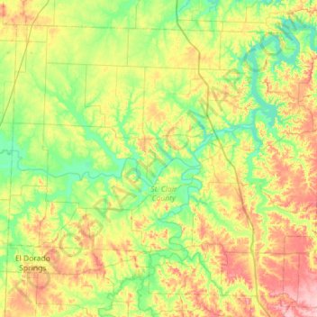
Name: St. Clair County topographic map, elevation, terrain.
Location: St. Clair County, Missouri, United States (37.82789 -94.06632 38.22105 -93.49692)
Average elevation: 255 m
Minimum elevation: 209 m
Maximum elevation: 339 m
Thank you for supporting this site ❤️
Make a donation
Make a donation
Other topographic maps
Click on a map to view its topography, its elevation and its terrain.