
Okuku River topographic map
Interactive map
Click on the map to display elevation.
About this map
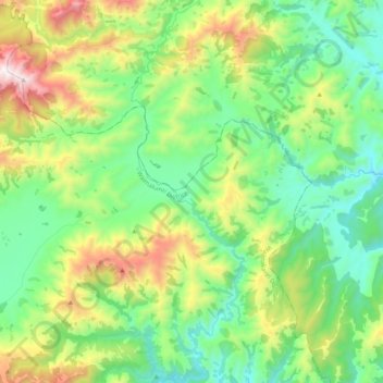
Name: Okuku River topographic map, elevation, terrain.
Location: Okuku River, Waimakariri District, Canterbury, New Zealand (-43.12823 172.32501 -42.97572 172.38678)
Average elevation: 653 m
Minimum elevation: 296 m
Maximum elevation: 1,456 m
Waimakariri District trails, hiking, mountain biking, running and outdoor activities
Other topographic maps
Click on a map to view its topography, its elevation and its terrain.
Loburn
New Zealand > Canterbury > Waimakariri District
The Loburn-Ashley fault zone is located from the northern banks of the Ashley River through to about Hodgsons road in the north, it runs parallel to the Ashley river. The Loburn fault, which runs along the south side of Hodgsons Road, is responsible for various terraced abandoned stream channels, wedge…
Average elevation: 110 m