
Make a donation
Harran topographic map
Click on the map to display elevation.
Make a donation
Harran
The precise location of the ancient great Ekhulkhul temple is unknown and no certain archaeological evidence of it has yet been found. It is likely that one of the major medieval buildings of Harran displaced the Elkhulkhul and were constructed on top of it, either the Harran Castle or the Grand Mosque. Writings from the Islamic period contradictingly claim that the castle or the mosque were the converted moon temple. The castle being on the site of the ancient temple is further supported by its higher elevation whereas the mosque is further supported by the finds of Babylonian inscriptions and four stelae of Nabonidus among its ruins. These inscriptions and stelae directly mention the Elkhulkhul. Additionally, the remains of an ancient altar with moon iconography have also been recovered from the ruins of the mosque. As a result, the mosque enjoys more scholarly support as the most likely site of the ancient temple.
Make a donation
About this map
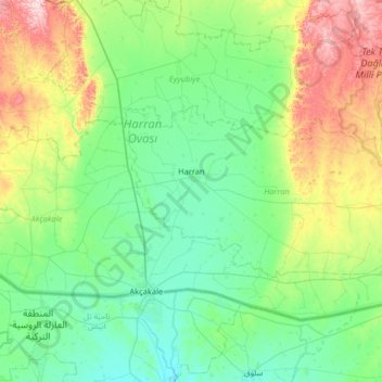
Name: Harran topographic map, elevation, terrain.
Location: Harran, Şanlıurfa, Southeastern Anatolia Region, Turkey (36.72714 38.91317 36.96045 39.56120)
Average elevation: 428 m
Minimum elevation: 329 m
Maximum elevation: 754 m
Make a donation
Other topographic maps
Click on a map to view its topography, its elevation and its terrain.
Make a donation
Make a donation
Istanbul
Istanbul, located in northwestern Turkey, is a city that is uniquely situated across two continents, Europe and Asia, divided by the Bosphorus Strait. The city’s topography is characterized by a complex blend of hills, valleys, and coastal plains, which create a varied and scenic landscape. The European side…
Average elevation: 57 m
Şanlıurfa
An important consideration in domestic architecture is mahremiyat, which could roughly be translated into English as "privacy" or "intimacy" but which carries stronger implications. This concept is especially important when it comes to relations between men and women – outside the extended family,…
Average elevation: 623 m
Ankara
Ankara has a cold semi-arid climate under the Köppen climate classification (BSk), while under the Trewartha climate classification, the city is classified as humid continental (Dc). Due to its elevation and inland location, Ankara has cold and snowy winters, and hot and dry summers. Rainfall occurs mostly…
Average elevation: 1,082 m
Make a donation
Kayseri
Kayseri sits at the foot of Mount Erciyes (Turkish: Erciyes Dağı), a dormant volcano that reaches an altitude of 3,916 metres (12,848 feet), more than 1,500 metres above the city's mean altitude. It contains a number of historic monuments, particularly from the Seljuk period. Tourists often pass through…
Average elevation: 1,345 m
Make a donation
Antalya
While the city itself only has modest elevation changes, Antalya has high mountains in all directions to its interior. With moisture being trapped, the local climate thus has high winter rainfall, while the interior bay setting result in very hot summers for a coastal city.
Average elevation: 111 m
Devrekani
Turkey > Devrekani > Devrekani
Devrekani is a town and district of the Kastamonu Province in the Black Sea region of Turkey. According to the 2000 census, population of the district is 15,855 of which 6,174 live in the town of Devrekani. The district covers an area of 599 km2 (231 sq mi), and the town lies at an elevation of 1,116 m (3,661…
Average elevation: 1,108 m
Make a donation
Salihli
The city of Salihli, the seat of the district, is located on İzmir-Ankara (E 96) highway and the parallel railway connections. The urban zone is situated on the slopes of Bozdağ mountain chain along the southern alluvial plains of the Gediz River. To the north and northeast of the plain extend two other…
Average elevation: 157 m