
Make a donation
Highgrove topographic map
Click on the map to display elevation.
Make a donation
Highgrove
The city of Riverside, California has plans to annex Highgrove in the near future. Currently at Spring Mountain Ranch community, Avalon, Cambria, and Sonoma (all opening by February 2022) are the three, newest largest master-planned communities being built at the Highgrove eastside area. Soon, Compass and Pinnacle at Summit Canyon by PulteGroup, at the south-east corner-end of Highgrove on the higher-elevation foothill, will open in 2023. These are the only known, brand-new homes currently available for sale, closer to Downtown Riverside and University of California, Riverside campus. In addition, 846 new urban-style townhomes by Lennar, plus its first new retail store in the area, will begin construction in 2023, next to the elementary school.
Make a donation
About this map
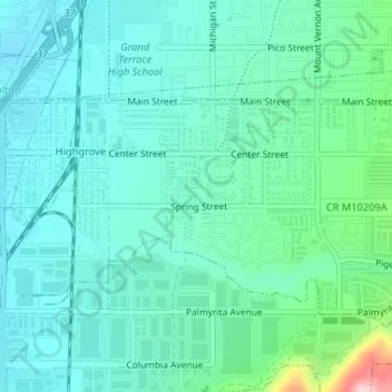
Name: Highgrove topographic map, elevation, terrain.
Location: Highgrove, Riverside County, California, United States (34.00614 -117.34462 34.01939 -117.31359)
Average elevation: 316 m
Minimum elevation: 271 m
Maximum elevation: 508 m
Make a donation
Other topographic maps
Click on a map to view its topography, its elevation and its terrain.
Palm Springs
United States > California > Riverside County
Palm Springs, located in the Coachella Valley, is characterized by striking topography shaped by both the Colorado Desert and surrounding mountain ranges. The city lies at an average elevation of around 480 feet (146 meters) above sea level. To the west, the San Bernardino Mountains rise dramatically, with…
Average elevation: 859 m
Menifee
United States > California > Riverside County
Menifee is a city in Riverside County, California, United States, and part of the Los Angeles Combined Statistical Area. The city is centrally located in Southern California in the Menifee Valley. It is almost 15 miles (24 km) north of Temecula and just north of Murrieta. Menifee is roughly 46 square miles…
Average elevation: 456 m
Make a donation
Palm Desert
United States > California > Riverside County
The elevation (City hall) is 224 feet (68 m) above sea level. Elevations vary from the lower northern half once covered in sand dunes to the upper slope southern cove (300–900 feet or 91–274 metres) all the way to the ridgeline at 1,000 feet (over 300 meters). Palm Desert is located in the Coachella…
Average elevation: 298 m
San Gorgonio Pass
United States > California > Riverside County
The San Gorgonio Pass, or Banning Pass, is a 2,600 ft (790 m) elevation gap on the rim of the Great Basin between the San Bernardino Mountains to the north and the San Jacinto Mountains to the south. The pass was formed by the San Andreas Fault, a major transform fault between the Pacific plate and the North…
Average elevation: 492 m
Bermuda Dunes
United States > California > Riverside County > Palm Desert
According to the United States Census Bureau, the CDP has a total area of 2.9 square miles (7.5 km2), all of it land. The official elevation of Bermuda Dunes is 30 feet (9.1 m) above sea level, but the surface drops by over 80 feet (24 m) from west to east.
Average elevation: 27 m
Make a donation
Make a donation
Cathedral City
United States > California > Riverside County > Cathedral City
Average elevation: 175 m
Lake Mathews
United States > California > Riverside County
Lake Mathews was constructed in a basin formerly traversed by Cajalco Creek; thus, any water flowing down the creek enters the reservoir. Cajalco Creek is a tributary of the Santa Ana River via Cajalco Canyon Creek into Temescal Creek. The original course of the creek, before 1933, can be seen on the US Dept.…
Average elevation: 430 m
Make a donation
Make a donation
Pinyon Pines
United States > California > Riverside County
It is located in a small valley between the San Jacinto Mountains and Santa Rosa Mountains, north of State Route 74. It takes its name from the Pinyon pine (Pinus monophylla) trees native to the area. Pinyon Pines sits at an elevation of approximately 4000 feet.
Average elevation: 1,276 m
Make a donation
Coachella
United States > California > Riverside County
The elevation is 68 feet (21 m) below sea level, as the eastern half of the Coachella Valley is below sea level. The saltwater lake, Salton Sea, 10 miles (16 km) south of Coachella, is 228 feet (69 m) below sea level.
Average elevation: -2 m
Whitewater
United States > California > Riverside County
Whitewater (formerly, White Water) is a census-designated place in Riverside County, California. It is directly off Interstate 10 halfway between North Palm Springs and Cabazon on the way from Palm Springs to Los Angeles. It is known as the site of the San Gorgonio Pass Wind Farm. The ZIP Code is 92282, and…
Average elevation: 530 m
Make a donation
Chuckwalla Mountains Wilderness
United States > California > Riverside County
Average elevation: 457 m
Make a donation
Make a donation
Coronita
United States > California > Riverside County
Coronita (Spanish for "Small crown") is a census-designated place in Riverside County, California. Coronita sits at an elevation of 630 feet (190 m). The 2010 United States census reported Coronita's population was 2,608.
Average elevation: 227 m
Make a donation
Pine Cove
United States > California > Riverside County > Idyllwild-Pine Cove
Average elevation: 1,791 m
Bannockburn Village
United States > California > Riverside County > Riverside > Bannockburn Village
Average elevation: 336 m
Make a donation
Mecca Hills Wilderness
United States > California > Riverside County > Coachella
Average elevation: 223 m
Make a donation
Arlington Station
United States > California > Riverside County > Riverside
Arlington Station (formerly, Arlington) is a former unincorporated community, now annexed to Riverside in Riverside County, California. It lies at an elevation of 817 feet (249 m). Arlington Station is located on the Atchison, Topeka and Santa Fe Railroad, 6 miles (9.7 km) southwest of downtown Riverside.
Average elevation: 252 m