
Thank you for supporting this site ❤️
Make a donation
Make a donation
Tulale topographic map
Click on the map to display elevation.
Thank you for supporting this site ❤️
Make a donation
Make a donation
About this map
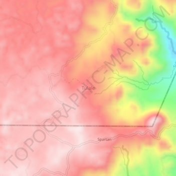
Name: Tulale topographic map, elevation, terrain.
Location: Tulale, Sultan Kudarat, Soccsksargen, Philippines (6.35770 124.51229 6.39770 124.55229)
Average elevation: 1,019 m
Minimum elevation: 683 m
Maximum elevation: 1,148 m
Thank you for supporting this site ❤️
Make a donation
Make a donation
Other topographic maps
Click on a map to view its topography, its elevation and its terrain.