
Thank you for supporting this site ❤️
Make a donation
Make a donation
Dovedale topographic map
Click on the map to display elevation.
Thank you for supporting this site ❤️
Make a donation
Make a donation
About this map
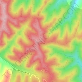
Name: Dovedale topographic map, elevation, terrain.
Location: Dovedale, Tasman, New Zealand (-41.33308 172.98438 -41.33298 172.98448)
Average elevation: 296 m
Minimum elevation: 179 m
Maximum elevation: 376 m
Tasman trails, hiking, mountain biking, running and outdoor activities
Thank you for supporting this site ❤️
Make a donation
Make a donation
Other topographic maps
Click on a map to view its topography, its elevation and its terrain.