
Landshut topographic map
Interactive map
Click on the map to display elevation.
About this map
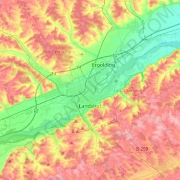
Name: Landshut topographic map, elevation, terrain.
Location: Landshut, Bavaria, Germany (48.50700 12.01822 48.59559 12.28449)
Average elevation: 445 m
Minimum elevation: 366 m
Maximum elevation: 527 m
Other topographic maps
Click on a map to view its topography, its elevation and its terrain.
Hochstaufen
Germany > Bavaria > Landkreis Berchtesgadener Land > Bad Reichenhall
At an altitude of 1,750 m is the Reichenhaller Haus, an alpine hut of the Deutscher Alpenverein (Section Bad Reichenhall).
Average elevation: 1,115 m
Pegnitz
Germany > Bavaria > Nürnberger Land > Hersbruck > Weiher
The Pegnitz has its source in the town of the same name at an altitude of 425 m (1,394 ft) and meets the Rednitz at 283 m (928 ft) in Fürth to form the Regnitz river. Shortly after the source, the Pegnitz unites with the 15 km (9.3 mi) long Fichtenohe while keeping the name of the shorter tributary. Some…
Average elevation: 357 m
Kellmünz an der Iller
Germany > Bavaria > Landkreis Neu-Ulm > Kellmünz a.d.Iller
Average elevation: 562 m
Zugspitze
Germany > Bavaria > Landkreis Garmisch-Partenkirchen > Grainau
The mountain rises eleven kilometres southwest of Garmisch-Partenkirchen and just under six kilometres east of Ehrwald. The border between Germany and Austria runs over the west summit; thus the Zugspitze massif belongs to the German state of Bavaria and the Austrian state of Tyrol. The municipalities…
Average elevation: 2,300 m