
Thank you for supporting this site ❤️
Make a donation
Make a donation
Sumbawa topographic map
Click on the map to display elevation.
Thank you for supporting this site ❤️
Make a donation
Make a donation
About this map
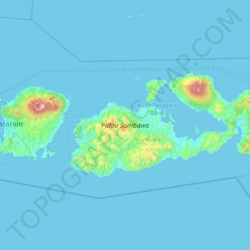
Name: Sumbawa topographic map, elevation, terrain.
Location: Sumbawa, West Nusa Tenggara, Lesser Sunda Islands, Indonesia (-9.10936 116.71527 -8.08046 119.19209)
Average elevation: 79 m
Minimum elevation: 0 m
Maximum elevation: 3,497 m
Thank you for supporting this site ❤️
Make a donation
Make a donation
Other topographic maps
Click on a map to view its topography, its elevation and its terrain.