
Tasman Lake topographic map
Interactive map
Click on the map to display elevation.
About this map
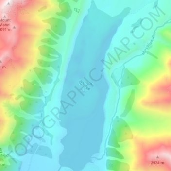
Name: Tasman Lake topographic map, elevation, terrain.
Location: Tasman Lake, Mackenzie District, Canterbury, New Zealand (-43.70794 170.17076 -43.65259 170.20314)
Average elevation: 1,060 m
Minimum elevation: 703 m
Maximum elevation: 2,147 m
Other topographic maps
Click on a map to view its topography, its elevation and its terrain.
Mount Blackburn
New Zealand > Canterbury > Mackenzie District
Mount Blackburn, Mackenzie District, Canterbury, New Zealand
Average elevation: 1,634 m
Twizel
New Zealand > Canterbury > Mackenzie District
Twizel, Mackenzie District, Canterbury, 7901, New Zealand
Average elevation: 472 m
Burkes Pass
New Zealand > Canterbury > Mackenzie District > Burkes Pass
Burkes Pass, Mackenzie District, Canterbury, New Zealand
Average elevation: 622 m
Mount Cook
New Zealand > Canterbury > Mackenzie District
Mount Cook, Mackenzie District, Canterbury, New Zealand
Average elevation: 2,920 m
Lake Benmore
New Zealand > Canterbury > Mackenzie District
Lake Benmore, Mackenzie District, Canterbury, New Zealand
Average elevation: 745 m
Lake Tekapo
New Zealand > Canterbury > Mackenzie District
Lake Tekapo, Mackenzie District, Canterbury, New Zealand
Average elevation: 1,025 m
Fairlie
New Zealand > Canterbury > Mackenzie District
Fairlie, Mackenzie District, Canterbury, 7925, New Zealand
Average elevation: 317 m
Lake Pukaki
New Zealand > Canterbury > Mackenzie District
Lake Pukaki, Mackenzie District, Canterbury, New Zealand
Average elevation: 886 m