
Thank you for supporting this site ❤️
Make a donation
Make a donation
Waipū Cove topographic map
Click on the map to display elevation.
Thank you for supporting this site ❤️
Make a donation
Make a donation
About this map
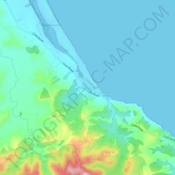
Name: Waipū Cove topographic map, elevation, terrain.
Location: Waipū Cove, Whangārei District, Northland, New Zealand (-36.04878 174.48423 -36.00878 174.52423)
Average elevation: 35 m
Minimum elevation: -2 m
Maximum elevation: 177 m
Whangarei District trails, hiking, mountain biking, running and outdoor activities
Thank you for supporting this site ❤️
Make a donation
Make a donation
Other topographic maps
Click on a map to view its topography, its elevation and its terrain.