
Thank you for supporting this site ❤️
Make a donation
Make a donation
Baracbac topographic map
Click on the map to display elevation.
Thank you for supporting this site ❤️
Make a donation
Make a donation
About this map
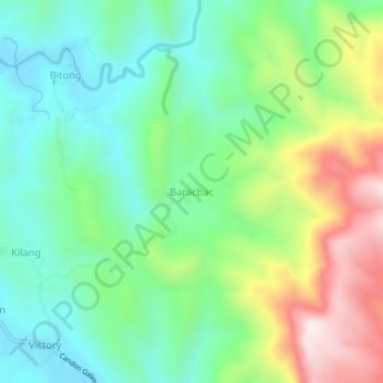
Name: Baracbac topographic map, elevation, terrain.
Location: Baracbac, Ilocos Sur, Ilocos Region, Philippines (17.16121 120.52449 17.20121 120.56449)
Average elevation: 276 m
Minimum elevation: 55 m
Maximum elevation: 716 m
Thank you for supporting this site ❤️
Make a donation
Make a donation
Other topographic maps
Click on a map to view its topography, its elevation and its terrain.