
Thank you for supporting this site ❤️
Make a donation
Make a donation
Bessang Pass topographic map
Click on the map to display elevation.
Thank you for supporting this site ❤️
Make a donation
Make a donation
About this map
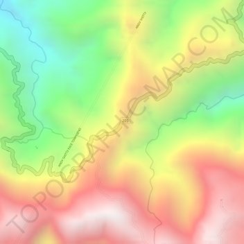
Name: Bessang Pass topographic map, elevation, terrain.
Location: Bessang Pass, Ilocos Sur, Ilocos Region, Philippines (16.95986 120.65746 16.96115 120.65829)
Average elevation: 1,377 m
Minimum elevation: 816 m
Maximum elevation: 1,845 m
Thank you for supporting this site ❤️
Make a donation
Make a donation
Other topographic maps
Click on a map to view its topography, its elevation and its terrain.
Thank you for supporting this site ❤️
Make a donation
Make a donation
Thank you for supporting this site ❤️
Make a donation
Make a donation
Thank you for supporting this site ❤️
Make a donation
Make a donation
Thank you for supporting this site ❤️
Make a donation
Make a donation
Thank you for supporting this site ❤️
Make a donation
Make a donation