
Thank you for supporting this site ❤️
Make a donation
Make a donation
Salomague topographic map
Click on the map to display elevation.
Thank you for supporting this site ❤️
Make a donation
Make a donation
About this map
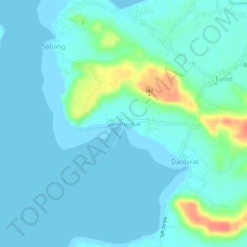
Name: Salomague topographic map, elevation, terrain.
Location: Salomague, Ilocos Sur, Ilocos Region, 2731, Philippines (17.76144 120.39495 17.80144 120.43495)
Average elevation: 9 m
Minimum elevation: 0 m
Maximum elevation: 53 m
Thank you for supporting this site ❤️
Make a donation
Make a donation
Other topographic maps
Click on a map to view its topography, its elevation and its terrain.