
Thank you for supporting this site ❤️
Make a donation
Make a donation
Bantay topographic map
Click on the map to display elevation.
Thank you for supporting this site ❤️
Make a donation
Make a donation
About this map
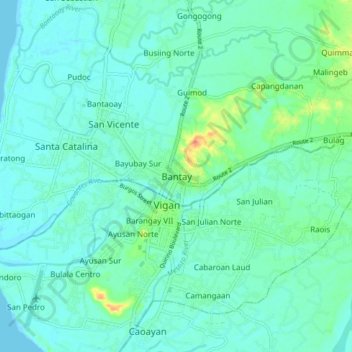
Name: Bantay topographic map, elevation, terrain.
Location: Bantay, Ilocos Sur, Ilocos Region, 2700, Philippines (17.54202 120.34963 17.62202 120.42963)
Average elevation: 8 m
Minimum elevation: 0 m
Maximum elevation: 36 m
Thank you for supporting this site ❤️
Make a donation
Make a donation
Other topographic maps
Click on a map to view its topography, its elevation and its terrain.