
Town of Clymer topographic map
Interactive map
Click on the map to display elevation.
About this map
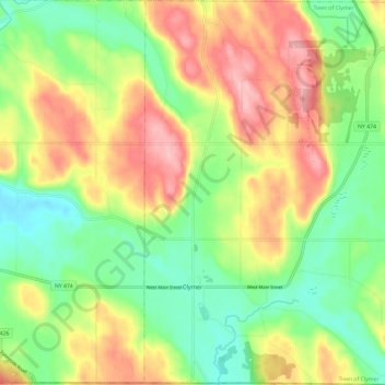
Name: Town of Clymer topographic map, elevation, terrain.
Location: Town of Clymer, Chautauqua County, New York, United States (41.99838 -79.64490 42.08614 -79.52762)
Average elevation: 488 m
Minimum elevation: 423 m
Maximum elevation: 572 m
Other topographic maps
Click on a map to view its topography, its elevation and its terrain.
Lamberton
United States > New York > Chautauqua County
Lamberton, Town of Pomfret, Chautauqua County, New York, 14166, United States
Average elevation: 229 m
Jamestown
United States > New York > Chautauqua County
Jamestown, Chautauqua County, New York, United States
Average elevation: 433 m
Jamestown West
United States > New York > Chautauqua County > Town of Ellicott
Jamestown West, Town of Ellicott, Chautauqua County, New York, United States
Average elevation: 441 m
Village of Fredonia
United States > New York > Chautauqua County
Village of Fredonia, Town of Pomfret, Chautauqua County, New York, 14063, United States
Average elevation: 227 m
Village of Panama
United States > New York > Chautauqua County
Village of Panama, Town of Harmony, Chautauqua County, New York, United States
Average elevation: 494 m
Findley Lake
United States > New York > Chautauqua County
Findley Lake, Chautauqua County, New York, 14736, United States
Average elevation: 463 m
Town of Arkwright
United States > New York > Chautauqua County
Town of Arkwright, Chautauqua County, New York, United States
Average elevation: 451 m
Village of Falconer
United States > New York > Chautauqua County > Town of Ellicott
Village of Falconer, Town of Ellicott, Chautauqua County, New York, United States
Average elevation: 399 m
Conewango Valley
United States > New York > Chautauqua County > Town of Ellington
Conewango Valley, Town of Ellington, Chautauqua County, New York, 14726, United States
Average elevation: 409 m
Town of Ripley
United States > New York > Chautauqua County
Town of Ripley, Chautauqua County, New York, 14775, United States
Average elevation: 325 m
Village of Bemus Point
United States > New York > Chautauqua County
Village of Bemus Point, Town of Ellery, Chautauqua County, New York, United States
Average elevation: 410 m
Kennedy
United States > New York > Chautauqua County
Kennedy, Town of Poland, Chautauqua County, New York, 14747, United States
Average elevation: 428 m
Van Buren Point
United States > New York > Chautauqua County > Town of Portland
Van Buren Point, Town of Portland, Chautauqua County, New York, 14166, United States
Average elevation: 177 m
Village of Brocton
United States > New York > Chautauqua County
Village of Brocton, Town of Portland, Chautauqua County, New York, 14716, United States
Average elevation: 220 m
Ashville
United States > New York > Chautauqua County
Ashville, Town of North Harmony, Chautauqua County, New York, 14710, United States
Average elevation: 429 m
Town of Ellington
United States > New York > Chautauqua County
Town of Ellington, Chautauqua County, New York, 14732, United States
Average elevation: 477 m
Village of Cassadaga
United States > New York > Chautauqua County
Village of Cassadaga, Town of Stockton, Chautauqua County, New York, United States
Average elevation: 418 m
Town of Chautauqua
United States > New York > Chautauqua County
Town of Chautauqua, Chautauqua County, New York, United States
Average elevation: 435 m
Dewittville
United States > New York > Chautauqua County > Town of Chautauqua
Dewittville, Town of Chautauqua, Chautauqua County, New York, 14728, United States
Average elevation: 425 m
Greenhurst
United States > New York > Chautauqua County
Greenhurst, Town of Ellery, Chautauqua County, New York, 14742, United States
Average elevation: 420 m
Irving
United States > New York > Chautauqua County
Irving, Town of Hanover, Chautauqua County, New York, 14081, United States
Average elevation: 185 m
Town of Gerry
United States > New York > Chautauqua County
Town of Gerry, Chautauqua County, New York, 14740, United States
Average elevation: 472 m
Village of Westfield
United States > New York > Chautauqua County > Town of Westfield
Village of Westfield, Town of Westfield, Chautauqua County, New York, 14787, United States
Average elevation: 224 m
Village of Sherman
United States > New York > Chautauqua County
Village of Sherman, Town of Sherman, Chautauqua County, New York, 14781, United States
Average elevation: 484 m
Frewsburg
United States > New York > Chautauqua County
Frewsburg, Town of Carroll, Chautauqua County, New York, 14738, United States
Average elevation: 400 m
Village of Sinclairville
United States > New York > Chautauqua County
Village of Sinclairville, Town of Charlotte, Chautauqua County, New York, 14782, United States
Average elevation: 459 m
Town of Cherry Creek
United States > New York > Chautauqua County
Town of Cherry Creek, Chautauqua County, New York, 14723, United States
Average elevation: 485 m
Stillwater
United States > New York > Chautauqua County > Town of Kiantone
Stillwater, Town of Kiantone, Carroll, Chautauqua County, New York, 14702, United States
Average elevation: 416 m
Town of Dunkirk
United States > New York > Chautauqua County
Town of Dunkirk, Chautauqua County, New York, United States
Average elevation: 205 m
Chautauqua Lake
United States > New York > Chautauqua County > Bemus Point
Chautauqua Lake, Bemus Point, Town of Chautauqua, Ellicott, Chautauqua County, New York, 14757, United States
Average elevation: 463 m
Town of North Harmony
United States > New York > Chautauqua County
Town of North Harmony, Chautauqua County, New York, United States
Average elevation: 466 m
Village of Celoron
United States > New York > Chautauqua County > Town of Ellicott
Village of Celoron, Town of Ellicott, Chautauqua County, New York, 14720, United States
Average elevation: 410 m
Town of Poland
United States > New York > Chautauqua County
Town of Poland, Chautauqua County, New York, 14747, United States
Average elevation: 440 m
Town of Portland
United States > New York > Chautauqua County
Town of Portland, Chautauqua County, New York, United States
Average elevation: 275 m
Forestville
United States > New York > Chautauqua County
Forestville, Town of Hanover, Chautauqua County, New York, United States
Average elevation: 298 m
Town of French Creek
United States > New York > Chautauqua County
Town of French Creek, Chautauqua County, New York, 14724, United States
Average elevation: 476 m
Town of Stockton
United States > New York > Chautauqua County
Town of Stockton, Chautauqua County, New York, United States
Average elevation: 442 m
Town of Sherman
United States > New York > Chautauqua County
Town of Sherman, Chautauqua County, New York, 14781, United States
Average elevation: 500 m
Belleview
United States > New York > Chautauqua County
Belleview, Town of Ellery, Chautauqua County, New York, 14742, United States
Average elevation: 432 m
Town of Ellicott
United States > New York > Chautauqua County
Town of Ellicott, Chautauqua County, New York, United States
Average elevation: 443 m
City of Dunkirk
United States > New York > Chautauqua County
City of Dunkirk, Chautauqua County, New York, 14048, United States
Average elevation: 188 m
Fluvanna
United States > New York > Chautauqua County > Fluvanna
Fluvanna, Town of Ellicott, Chautauqua County, New York, 14720, United States
Average elevation: 420 m
Jamestown
United States > New York > Chautauqua County > Jamestown
Jamestown, Chautauqua County, New York, 14702, United States
Average elevation: 472 m
Emory Park
United States > New York > Chautauqua County > City of Jamestown
Emory Park, City of Jamestown, Chautauqua County, New York, 14701, United States
Average elevation: 433 m
Village of Silver Creek
United States > New York > Chautauqua County
Village of Silver Creek, Town of Hanover, Chautauqua County, New York, 14136, United States
Average elevation: 194 m
Gerry
United States > New York > Chautauqua County > Gerry
Gerry, Chautauqua County, New York, 14740, United States
Average elevation: 428 m
French Creek
United States > New York > Chautauqua County > French Creek
French Creek, Chautauqua County, New York, 14724, United States
Average elevation: 459 m