
Makkah Al Mukarramah topographic map
Interactive map
Click on the map to display elevation.
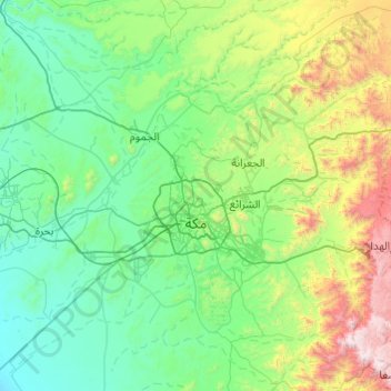
Makkah Al Mukarramah topographic map, elevation, terrain
Makkah Al Mukarramah
Mecca is located in the Hejaz region, a 200 km (124 mi) wide strip of mountains separating the Nafud desert from the Red Sea. The city is situated in a valley with the same name around 70 km (44 mi) west of the port city of Jeddah. Mecca is one of the lowest cities in elevation in the Hejaz region, located at an elevation of 277 m (909 ft) above sea level at 21º23' north latitude and 39º51' east longitude. Mecca is divided into 34 districts.
About this map
Name: Makkah Al Mukarramah topographic map, elevation, terrain.
Location: Makkah Al Mukarramah, Makkah Region, Saudi Arabia (21.11982 39.50586 21.84804 40.47561)
Average elevation: 479 m
Minimum elevation: 18 m
Maximum elevation: 2,588 m
Other topographic maps
Click on a map to view its topography, its elevation and its terrain.
At Ta'if
Taif (Arabic: اَلطَّائِفُ, romanized: aṭ-Ṭāʾif, lit. 'The circulated or encircled', Hejazi Arabic pronunciation: [atˤˈ tˤaː(j)ɪf]) is a city and governorate in the Mecca Province of Saudi Arabia. Located at an elevation of 1,879 m (6,165 ft) in the slopes of the Hijaz Mountains,…
Average elevation: 1,742 m