
Make a donation
Peloponnese topographic map
Click on the map to display elevation.
Make a donation
About this map
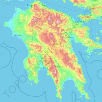
Name: Peloponnese topographic map, elevation, terrain.
Location: Peloponnese, Greece (36.38525 21.10507 38.34141 23.52452)
Average elevation: 257 m
Minimum elevation: -6 m
Maximum elevation: 2,293 m
Make a donation
Other topographic maps
Click on a map to view its topography, its elevation and its terrain.
Agia Pelagia
Greece > Region of Crete > Lasithi Regional Unit > Agios Nikolaos Municipal Unit
Average elevation: 354 m
Patras
Greece > Peloponnese, Western Greece and the Ionian > Achaia Regional Unit
A central feature of the urban geography of Patras is its division into upper and lower sections. This is the result of an interplay between natural geography and human settlement patterns; the lower section of the city (Kato Poli), which includes the 19th-century urban core and the port, is adjacent to the…
Average elevation: 283 m
Alexandreia
Greece > Macedonia and Thrace > Imathia Regional Unit
Alexandreia is a located in the vast plain north of the river Aliakmonas and west of the river Axios, named Kampania or also Roumlouki. Its economy is chiefly based on the agricultural utilization of the surrounding fields. The area around Alexandreia has the greatest production of peaches in Greece and…
Average elevation: 24 m
Make a donation
Tilisos
Greece > Region of Crete > Heraklion Regional Unit > Tylissos Municipal Unit
Average elevation: 243 m
Devil's tower
Greece > Thessaly and Central Greece > Trikala Regional Unit > Kalabaka
Average elevation: 414 m
Make a donation
Λιτόχωρο
Greece > Macedonia and Thrace > Pieria Regional Unit
At an altitude of 850 m, beside the Enipeas gorge, Saint Dionysios built a monastery. Founded 1542, its name was Agia Triada, what means Holy Trinity, later changed to the name of the Saint. Plundered and burned several times in its history, it received the final blow from German troops in April 1943.
Average elevation: 396 m
Nafplio
Greece > Peloponnese, Western Greece and the Ionian > Argolis Regional Unit > Municipal Unit of Nafplio
Average elevation: 36 m
Make a donation
Margarites
Greece > Aegean > Samos Regional Unit > Municipal Unit of Vathy > Manolates
Average elevation: 308 m
Kouroutas
Greece > Peloponnese, Western Greece and the Ionian > Elis Regional Unit > Amaliada Municipal Unit
Average elevation: 5 m
Athens
Greece > Attica > Regional Unit of Central Athens
Owing to the rain shadow of the Pindus Mountains, annual precipitation of Athens is lower than most other parts of Greece, especially western Greece. As an example, Ioannina receives around 1,300 mm (51 in) per year, and Agrinio around 800 mm (31 in) per year. Daily average highs for July have been measured…
Average elevation: 168 m
Make a donation
Corinth
Greece > Peloponnese, Western Greece and the Ionian > Corinthia Regional Unit
Average elevation: 185 m
Anixiatiko
Greece > Thessaly and Central Greece > Karditsa Regional Unit > Anthochori
Average elevation: 1,083 m
Olympus
Greece > Attica > Regional Unit of North Athens > Municipal Unit of Psychiko
Average elevation: 204 m
Make a donation
Make a donation