
Kirkland topographic map
Interactive map
Click on the map to display elevation.
About this map
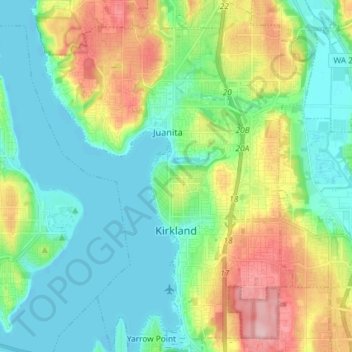
Name: Kirkland topographic map, elevation, terrain.
Location: Kirkland, King County, Washington, United States (47.64243 -122.26188 47.74078 -122.14935)
Average elevation: 58 m
Minimum elevation: -1 m
Maximum elevation: 184 m
According to the United States Census Bureau, the city has a total area of 17.83 square miles (46.18 km2), of which 17.818 square miles (46.15 km2) are land and 0.012 square miles (0.03 km2) are water.[19] The elevation varies from 14 to 500 feet (150 m) above sea level.
Other topographic maps
Click on a map to view its topography, its elevation and its terrain.
Skykomish
United States > Washington > King County
Skykomish, King County, Washington, United States
Average elevation: 441 m
Renton
United States > Washington > King County
Renton, King County, Washington, United States
Average elevation: 83 m
Seattle
United States > Washington > King County
Seattle, King County, Washington, United States
Average elevation: 40 m
Issaquah
United States > Washington > King County > Issaquah
Issaquah, King County, Washington, United States
Average elevation: 164 m