
Thank you for supporting this site ❤️
Make a donation
Make a donation
Rathmell topographic map
Click on the map to display elevation.
Thank you for supporting this site ❤️
Make a donation
Make a donation
About this map
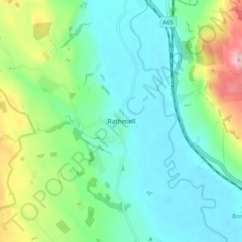
Name: Rathmell topographic map, elevation, terrain.
Location: Rathmell, North Yorkshire, England, BD24 0FG, United Kingdom (54.01519 -2.32040 54.05519 -2.28040)
Average elevation: 172 m
Minimum elevation: 121 m
Maximum elevation: 315 m
Thank you for supporting this site ❤️
Make a donation
Make a donation
Other topographic maps
Click on a map to view its topography, its elevation and its terrain.
Thank you for supporting this site ❤️
Make a donation
Make a donation
Thimbleby & Osmotherly Show field
United Kingdom > England > North Yorkshire > Thimbleby
Average elevation: 152 m
Thank you for supporting this site ❤️
Make a donation
Make a donation