
Thank you for supporting this site ❤️
Make a donation
Make a donation
Crich Carr topographic map
Click on the map to display elevation.
Thank you for supporting this site ❤️
Make a donation
Make a donation
About this map
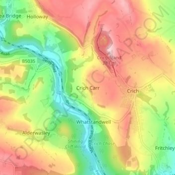
Name: Crich Carr topographic map, elevation, terrain.
Average elevation: 171 m
Minimum elevation: 64 m
Maximum elevation: 278 m
Thank you for supporting this site ❤️
Make a donation
Make a donation
Other topographic maps
Click on a map to view its topography, its elevation and its terrain.
Nottingham Canal
United Kingdom > England > Derbyshire > Amber Valley > Langley Mill
Average elevation: 77 m