
St Ives topographic map
Interactive map
Click on the map to display elevation.
About this map
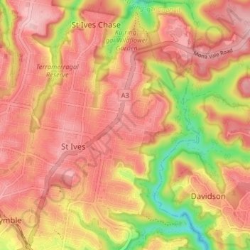
Name: St Ives topographic map, elevation, terrain.
Average elevation: 125 m
Minimum elevation: 9 m
Maximum elevation: 188 m
Other topographic maps
Click on a map to view its topography, its elevation and its terrain.
Milsons Point
Australia > New South Wales > Sydney
Milsons Point, Lower North Shore, Sydney, North Sydney Council, New South Wales, 2061, Australia
Average elevation: 21 m
Upper North Shore
Australia > New South Wales > Sydney
Upper North Shore, Sydney, Ku-ring-gai Council, New South Wales, Australia
Average elevation: 119 m
Watsons Bay
Australia > New South Wales > Sydney
Watsons Bay, Eastern Suburbs, Sydney, Woollahra Municipal Council, New South Wales, 2030, Australia
Average elevation: 5 m
Bondi
Australia > New South Wales > Sydney
Bondi, Eastern Suburbs, Sydney, Waverley Council, New South Wales, 2026, Australia
Average elevation: 49 m
Hills District
Australia > New South Wales > Sydney
Hills District, Sydney, The Hills Shire Council, New South Wales, Australia
Average elevation: 91 m
Hazelbrook
Australia > New South Wales > Sydney
Hazelbrook, Sydney, Blue Mountains City Council, New South Wales, 2779, Australia
Average elevation: 610 m
Mount Annan
Australia > New South Wales > Sydney
Mount Annan, Sydney, Campbelltown City Council, New South Wales, 2563, Australia
Average elevation: 115 m
Anzac Park
Australia > New South Wales > Sydney
Anzac Park, West Ryde, Sydney, Council of the City of Ryde, New South Wales, 2114, Australia
Average elevation: 45 m
Baulkham Hills
Australia > New South Wales > Sydney
Baulkham Hills, Hills District, Sydney, The Hills Shire Council, New South Wales, 2153, Australia
Average elevation: 93 m
Marayong
Australia > New South Wales > Sydney
Marayong, Sydney, Blacktown City Council, New South Wales, 2148, Australia
Average elevation: 42 m
Toongabbie
Australia > New South Wales > Sydney
Toongabbie, Sydney, City of Parramatta Council, New South Wales, 2146, Australia
Average elevation: 43 m
South Penrith
Australia > New South Wales > Sydney > Penrith
South Penrith, Penrith, Sydney, Penrith City Council, New South Wales, 2750, Australia
Average elevation: 48 m
Glenwood
Australia > New South Wales > Sydney
Glenwood, Sydney, Blacktown City Council, New South Wales, 2768, Australia
Average elevation: 69 m
Quakers Hill
Australia > New South Wales > Sydney
Quakers Hill, Sydney, Blacktown City Council, New South Wales, 2763, Australia
Average elevation: 35 m
Kings Langley
Australia > New South Wales > Sydney
Kings Langley, Sydney, Blacktown City Council, New South Wales, 2147, Australia
Average elevation: 69 m
Constitution Hill
Australia > New South Wales > Sydney
Constitution Hill, Sydney, City of Parramatta Council, New South Wales, 2145, Australia
Average elevation: 35 m
Greystanes
Australia > New South Wales > Sydney
Greystanes, Sydney, Cumberland City Council, New South Wales, 2145, Australia
Average elevation: 53 m
Winston Hills
Australia > New South Wales > Sydney
Winston Hills, Sydney, City of Parramatta Council, New South Wales, 2153, Australia
Average elevation: 58 m
Regents Park
Australia > New South Wales > Sydney
Regents Park, Sydney, Cumberland City Council, New South Wales, 2143, Australia
Average elevation: 34 m
Campbelltown
Australia > New South Wales > Sydney
Campbelltown, Sydney, Campbelltown City Council, New South Wales, 2560, Australia
Average elevation: 96 m
Caringbah
Australia > New South Wales > Sydney
Caringbah, Sydney, Sutherland Shire Council, New South Wales, 2229, Australia
Average elevation: 17 m
Denham Court
Australia > New South Wales > Sydney
Denham Court, Sydney, Campbelltown City Council, New South Wales, 2565, Australia
Average elevation: 79 m
Sutherland
Australia > New South Wales > Sydney
Sutherland, Sutherland Shire, Sydney, Sutherland Shire Council, New South Wales, 2232, Australia
Average elevation: 80 m
Canterbury
Australia > New South Wales > Sydney
Canterbury, Inner West, Sydney, Canterbury-Bankstown Council, New South Wales, 2193, Australia
Average elevation: 24 m
Mount Pritchard
Australia > New South Wales > Sydney
Mount Pritchard, Sydney, Fairfield City Council, New South Wales, 2170, Australia
Average elevation: 34 m
St Marys
Australia > New South Wales > Sydney
St Marys, Sydney, Penrith City Council, New South Wales, 2760, Australia
Average elevation: 37 m
Pittwater
Australia > New South Wales > Sydney
Pittwater, Northern Beaches, Sydney, Northern Beaches Council, New South Wales, Australia
Average elevation: 50 m
Artarmon
Australia > New South Wales > Sydney
Artarmon, Sydney, Willoughby City Council, New South Wales, 2064, Australia
Average elevation: 81 m
Middle Harbour
Australia > New South Wales > Sydney
Middle Harbour, Sydney, New South Wales, 2087, Australia
Average elevation: 56 m
Warrawee
Australia > New South Wales > Sydney
Warrawee, Sydney, Ku-ring-gai Council, Upper North Shore, New South Wales, 2074, Australia
Average elevation: 161 m
Wetherill Park
Australia > New South Wales > Sydney
Wetherill Park, Sydney, Fairfield City Council, New South Wales, 2164, Australia
Average elevation: 52 m
Edmondson Park
Australia > New South Wales > Sydney
Edmondson Park, Sydney, Liverpool City Council, New South Wales, 2174, Australia
Average elevation: 56 m
Penshurst
Australia > New South Wales > Sydney
Penshurst, Sydney, Georges River Council, St George, New South Wales, 2222, Australia
Average elevation: 45 m
Cockatoo Island
Australia > New South Wales > Sydney
Cockatoo Island, Sydney, New South Wales, 2041, Australia
Average elevation: 46 m
Cabramatta
Australia > New South Wales > Sydney
Cabramatta, Sydney, Fairfield City Council, New South Wales, 2166, Australia
Average elevation: 16 m
Epping
Australia > New South Wales > Sydney
Epping, Sydney, City of Parramatta Council, New South Wales, 2121, Australia
Average elevation: 96 m
Mosman
Australia > New South Wales > Sydney
Mosman, Sydney, Mosman Municipal Council, Lower North Shore, New South Wales, 2088, Australia
Average elevation: 28 m
Manly
Australia > New South Wales > Sydney
Manly, Sydney, Northern Beaches Council, New South Wales, 2095, Australia
Average elevation: 17 m
Belrose
Australia > New South Wales > Sydney
Belrose, Sydney, Northern Beaches Council, Northern Beaches, New South Wales, 2085, Australia
Average elevation: 124 m
Killara
Australia > New South Wales > Sydney
Killara, Sydney, Ku-ring-gai Council, Upper North Shore, New South Wales, 2071, Australia
Average elevation: 86 m
Maroubra
Australia > New South Wales > Sydney
Maroubra, Sydney, Randwick City Council, New South Wales, 2035, Australia
Average elevation: 27 m
Katoomba
Australia > New South Wales > Sydney > Katoomba
Katoomba, Sydney, Blue Mountains City Council, New South Wales, 2780, Australia
Average elevation: 912 m
Coogee
Australia > New South Wales > Sydney
Coogee, Sydney, Randwick City Council, New South Wales, 2034, Australia
Average elevation: 35 m
Dulwich Hill
Australia > New South Wales > Sydney
Dulwich Hill, Sydney, Inner West Council, New South Wales, 2203, Australia
Average elevation: 27 m
Marrickville
Australia > New South Wales > Sydney
Marrickville, Sydney, Inner West Council, New South Wales, 2204, Australia
Average elevation: 17 m
Mount Druitt
Australia > New South Wales > Sydney
Mount Druitt, Sydney, Blacktown City Council, New South Wales, 2770, Australia
Average elevation: 52 m
Sydney Water Supply Canal
Australia > New South Wales > Sydney
Sydney Water Supply Canal, Sydney, Liverpool City Council, New South Wales, 2178, Australia
Average elevation: 82 m
Ultimo
Australia > New South Wales > Sydney
Ultimo, Sydney, Council of the City of Sydney, New South Wales, 2007, Australia
Average elevation: 28 m
Haymarket
Australia > New South Wales > Sydney
Haymarket, Sydney, Council of the City of Sydney, New South Wales, 2000, Australia
Average elevation: 31 m
Schofields
Australia > New South Wales > Sydney
Schofields, Sydney, Blacktown City Council, New South Wales, 2762, Australia
Average elevation: 32 m