
Murchison topographic map
Interactive map
Click on the map to display elevation.
About this map
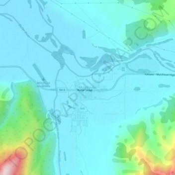
Name: Murchison topographic map, elevation, terrain.
Location: Murchison, 7007, New Zealand (-41.81953 172.30868 -41.77953 172.34868)
Average elevation: 235 m
Minimum elevation: 151 m
Maximum elevation: 757 m
New Zealand trails, hiking, mountain biking, running and outdoor activities
Other topographic maps
Click on a map to view its topography, its elevation and its terrain.
South Island
The South Island (Māori: Te Waipounamu, lit. 'the waters of Greenstone', officially South Island or Te Waipounamu or archaically New Munster) is the largest of the three major islands of New Zealand in surface area, the other being the smaller but more populous North Island and sparsely populated Stewart…
Average elevation: 201 m
Napier
The topography puts Napier in danger from a tsunami, as the centre of the commercial city is near sea level – should the sea ever crest Marine Parade, the sea would run through to Ahuriri. Furthermore, by virtue of its pre-1931 existence, the bulk of Napier is susceptible to soil liquefaction, the risk…
Average elevation: 12 m
Stewart Island
Although the clay soil is not very fertile, the high rainfall and warm weather mean that the island is densely forested throughout. Native plants include the world's southernmost dense forest of podocarps (southern conifers) and hardwoods such as rātā and kāmahi in the lowland areas with mānuka shrubland…
Average elevation: 63 m
Napier
The city is on Napier Hill and the surrounding Heretaunga Plains at the southeastern edge of Hawke Bay, a large semi-circular bay that dominates the east coast of New Zealand's North Island. The coastline of the city was substantially altered by a large earthquake in 1931. The topography puts Napier in danger…
Average elevation: 12 m
Southland
Fiordland has a wet mountain climate though conditions vary due to altitude and exposure. Rainfall is the highest in the country and varies between 6,500 and 7,500 mm annually. The farthest coastal reaches of Fiordland are characterized by a limited temperature range with increasing rainfall at higher…
Average elevation: 229 m
Saint Arnaud Range
New Zealand > Marlborough > Marlborough District
The lower elevations are covered primarily in beech forests, while higher elevations (above about 5,000 feet) are alpine.
Average elevation: 1,249 m
Auckland Islands
The vegetation of the islands sub-divides into distinct altitudinal zones. Inland from the salt-spray zone, the fringes of the islands predominantly feature forests of southern rātā Metrosideros umbellata, and in places the subantarctic tree daisy (Olearia lyallii), probably introduced by sealers. Above this…
Average elevation: 51 m
Stewart Island
Although the clay soil is not very fertile, the high rainfall and warm weather mean that the island is densely forested throughout. Native plants include the world's southernmost dense forest of podocarps (southern conifers) and hardwoods such as rātā and kāmahi in the lowland areas with mānuka shrubland…
Average elevation: 63 m
Te Tii Waitangi Marae
New Zealand > Northland > Far North District > Bay of Islands-Whangaroa Community > Paihia
Average elevation: 14 m
The Remarkables
New Zealand > Otago > Queenstown-Lakes District
The area contains a number of beautiful features, such as Lake Alta, a small lake nestled within a natural amphitheatre at the head of a glacial valley (a ‘cirque’) and below the towering Double Cone peaks. There are a number of high altitude walks in the Remarkables Conservation Area including Lake Alta…
Average elevation: 1,200 m
Hope Reef
New Zealand > Northland > Far North District > Bay of Islands-Whangaroa Community
Average elevation: 7 m
Kitchener Park
New Zealand > Manawatu-Whanganui > Manawatū District > Feilding
Average elevation: 63 m
Lake Ōmāpere
New Zealand > Northland > Far North District > Kaikohe-Hokianga Community
Average elevation: 243 m
Lake Ōkareka
New Zealand > Bay of Plenty > Rotorua Lakes District > Lake Okareka
Average elevation: 392 m
Tasman Glacier
New Zealand > Canterbury > Mackenzie District
At 23.5 kilometres (14.6 mi) in length, Tasman Glacier is still New Zealand's longest glacier, despite shrinking considerably from the 1990s onwards. It is as much as 4 kilometres (2.5 mi) wide and 600 metres (2,000 ft) thick, and lies entirely within the borders of Aoraki / Mount Cook National Park. The…
Average elevation: 1,884 m
Auckland Islands
The vegetation of the islands sub-divides into distinct altitudinal zones. Inland from the salt-spray zone, the fringes of the islands predominantly feature forests of southern rātā Metrosideros umbellata, and in places the subantarctic tree daisy (Olearia lyallii), probably introduced by sealers. Above this…
Average elevation: 51 m
Lake Ōkareka
New Zealand > Bay of Plenty > Rotorua Lakes District > Lake Okareka
Average elevation: 392 m
Lake Ōkareka
New Zealand > Bay of Plenty > Rotorua Lakes District > Lake Okareka
Average elevation: 392 m