
Make a donation
Napier topographic map
Click on the map to display elevation.
Make a donation
Napier
The topography puts Napier in danger from a tsunami, as the centre of the commercial city is near sea level – should the sea ever crest Marine Parade, the sea would run through to Ahuriri. Furthermore, by virtue of its pre-1931 existence, the bulk of Napier is susceptible to soil liquefaction, the risk classed as Very High for the main urban area excluding the hill.
Make a donation
About this map
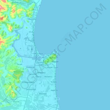
Name: Napier topographic map, elevation, terrain.
Location: Napier, Hawke's Bay, New Zealand (-39.57047 176.81127 -39.38819 176.92593)
Average elevation: 12 m
Minimum elevation: -3 m
Maximum elevation: 276 m
Hawke's Bay trails, hiking, mountain biking, running and outdoor activities
Make a donation
Other topographic maps
Click on a map to view its topography, its elevation and its terrain.
Make a donation
Make a donation
Make a donation
Make a donation
Make a donation
Te Mata Peak
New Zealand > Hawke's Bay > Hastings District > Hastings
Te Mata Peak is a peak south of Hastings rising up to 399m in the Te Mata Hills in the Hawke's Bay region of New Zealand. A sealed road leads to the popular lookout at the summit, as well as many trails for hikers and mountain bikers. The Hastings suburb of Havelock North is situated at the base of the peak.…
Average elevation: 144 m
Make a donation
Taumatawhakatangihangakōauauotamateapōkaiwhenuakitānatahu
New Zealand > Hawke's Bay > Central Hawke's Bay District
Average elevation: 199 m
Make a donation
Make a donation
Taumatawhakatangihangakōauauotamateapōkaiwhenuakitānatahu
New Zealand > Hawke's Bay > Central Hawke's Bay District
Average elevation: 199 m
Make a donation
Make a donation