
Thank you for supporting this site ❤️
Make a donation
Make a donation
Weybridge topographic map
Click on the map to display elevation.
Thank you for supporting this site ❤️
Make a donation
Make a donation
About this map
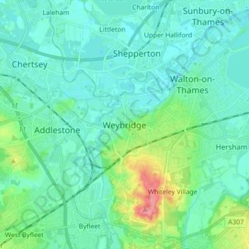
Name: Weybridge topographic map, elevation, terrain.
Average elevation: 21 m
Minimum elevation: 7 m
Maximum elevation: 82 m
Thank you for supporting this site ❤️
Make a donation
Make a donation
Other topographic maps
Click on a map to view its topography, its elevation and its terrain.
Cobham
United Kingdom > England > Surrey > Elmbridge
The River Mole runs through Cobham, with a visitor area and well-surfaced path by the mill in the High Street, dividing the remaining agricultural parts of Cobham in the west and south. Elevation reaches a minimum here of 20 metres (66 ft) above sea level.
Average elevation: 28 m