
Thank you for supporting this site ❤️
Make a donation
Make a donation
Clachan topographic map
Click on the map to display elevation.
Thank you for supporting this site ❤️
Make a donation
Make a donation
About this map
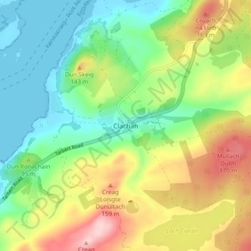
Name: Clachan topographic map, elevation, terrain.
Location: Clachan, Argyll and Bute, Scotland, PA29 6YP, United Kingdom (55.72678 -5.58178 55.76678 -5.54178)
Average elevation: 75 m
Minimum elevation: -1 m
Maximum elevation: 198 m
Thank you for supporting this site ❤️
Make a donation
Make a donation
Other topographic maps
Click on a map to view its topography, its elevation and its terrain.
Thank you for supporting this site ❤️
Make a donation
Make a donation
Thank you for supporting this site ❤️
Make a donation
Make a donation