
Thank you for supporting this site ❤️
Make a donation
Make a donation
Ardrishaig topographic map
Click on the map to display elevation.
Thank you for supporting this site ❤️
Make a donation
Make a donation
About this map
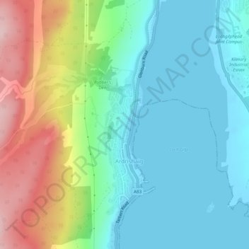
Name: Ardrishaig topographic map, elevation, terrain.
Location: Ardrishaig, Argyll and Bute, Scotland, United Kingdom (56.00666 -5.45567 56.03215 -5.44184)
Average elevation: 66 m
Minimum elevation: 0 m
Maximum elevation: 223 m
Thank you for supporting this site ❤️
Make a donation
Make a donation
Other topographic maps
Click on a map to view its topography, its elevation and its terrain.
Thank you for supporting this site ❤️
Make a donation
Make a donation
Kilmichael of Inverlussa
United Kingdom > Scotland > Argyll and Bute > Achnamara
Average elevation: 99 m
Thank you for supporting this site ❤️
Make a donation
Make a donation
Thank you for supporting this site ❤️
Make a donation
Make a donation