
Make a donation
Tauranga City topographic map
Click on the map to display elevation.
Make a donation
About this map
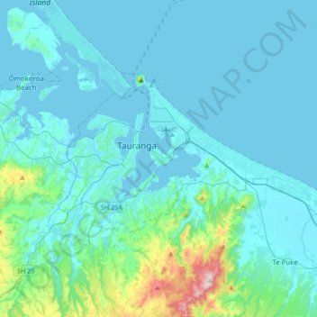
Name: Tauranga City topographic map, elevation, terrain.
Location: Tauranga City, Bay of Plenty, New Zealand (-37.77056 176.07411 -37.62409 176.41504)
Average elevation: 55 m
Minimum elevation: -1 m
Maximum elevation: 546 m
Bay of Plenty trails, hiking, mountain biking, running and outdoor activities
Make a donation
Other topographic maps
Click on a map to view its topography, its elevation and its terrain.
Make a donation
Make a donation
Papamoa Hills Regional Park
New Zealand > Bay of Plenty > Western Bay of Plenty District
Average elevation: 58 m
Make a donation
Make a donation
Punaromia
New Zealand > Bay of Plenty > Rotorua Lakes District > Lake Tarawera
Average elevation: 443 m
Make a donation
Lake Rotoiti
New Zealand > Bay of Plenty > Rotorua Lakes District > Rotoiti > Hinehopu
Average elevation: 349 m
Make a donation
Tikitapu / Blue Lake
New Zealand > Bay of Plenty > Rotorua Lakes District > Rotorua
Average elevation: 520 m
Make a donation
Make a donation
Make a donation
Make a donation
Make a donation
Make a donation
Make a donation
Make a donation
Make a donation
Lake Rotoiti
New Zealand > Bay of Plenty > Rotorua Lakes District > Rotoiti > Hinehopu
Average elevation: 349 m
Make a donation
Make a donation
Make a donation
Make a donation