
Make a donation
Aragon topographic map
Click on the map to display elevation.
Make a donation
Aragon
There are two main types of climate in Aragón, the Semi-arid climate and the Oceanic climate. Its irregular orography creates several microclimates throughout the entire community. From the High mountain Alpine climate of the central Pyrenees to the north, with perpetual ice (glaciers), to the Humid subtropical climate (which is very common in Huesca's lower altitude areas) to the steppe or semi-desert zones, such as the Monegros Desert, passing through the intense continental climate of the Teruel-Daroca area and the Mediterranean climate in the southern areas bordering Castilla La Mancha and the Valencian Community.
Make a donation
About this map
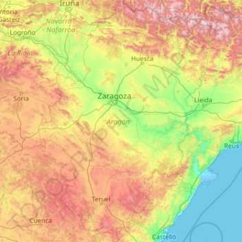
Name: Aragon topographic map, elevation, terrain.
Location: Aragon, Spain (39.84678 -2.17367 42.92450 0.77131)
Average elevation: 778 m
Minimum elevation: -5 m
Maximum elevation: 3,311 m
Make a donation
Other topographic maps
Click on a map to view its topography, its elevation and its terrain.
Pyrenees
The Pyrenees are a mountain range straddling the border of France and Spain. They extend nearly 500 km (310 mi) from their union with the Cantabrian Mountains to Cap de Creus on the Mediterranean coast, reaching a maximum altitude of 3,404 metres (11,168 ft) at the peak of Aneto.
Average elevation: 491 m
Make a donation
Make a donation
Montenegral Alto
Spain > Andalusia > Campo de Gibraltar > San Martín del Tesorillo
Average elevation: 71 m
Make a donation
Soil
Spain > Autonomous Community of the Basque Country > Montaña Alavesa/Arabako Mendialdea
Average elevation: 898 m
Make a donation
Make a donation
Santiago de Compostela
Spain > Galicia > Santiago > Santiago de Compostela
The cathedral borders the main plaza of the old and well-preserved city. According to medieval legend, the remains of the apostle James were brought to Galicia for burial; in 813, the light of a bright star guided a shepherd who was watching his flock at night to the burial site in Santiago de Compostela. This…
Average elevation: 248 m
Donostia / San Sebastián
Spain > Autonomous Community of the Basque Country > Donostialdea > Donostia / San Sebastián
Average elevation: 134 m
Make a donation
Madrid
Spain > Community of Madrid > Área metropolitana de Madrid y Corredor del Henares > Madrid
Average elevation: 650 m
Penyagolosa
Spain > Valencian Community > Castelló / Castellón > Xodos / Chodos
Average elevation: 1,417 m
Make a donation
Make a donation