
El Cairo topographic map
Interactive map
Click on the map to display elevation.
About this map
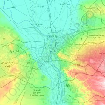
Name: El Cairo topographic map, elevation, terrain.
Location: El Cairo, Egipto (29.74831 31.22003 30.32092 31.90901)
Average elevation: 112 m
Minimum elevation: 2 m
Maximum elevation: 522 m
Other topographic maps
Click on a map to view its topography, its elevation and its terrain.
ميدان عبد المنعم رياض
Egipto > El Cairo > El Cairo > ميدان عبد المنعم رياض
ميدان عبد المنعم رياض, El Cairo, 12344, Egipto
Average elevation: 27 m
مدينة القاهرة الجديدة
Egipto > El Cairo > مدينة القاهرة الجديدة
مدينة القاهرة الجديدة, El Cairo, Egipto
Average elevation: 242 m