
Huambo Province topographic map
Interactive map
Click on the map to display elevation.
About this map
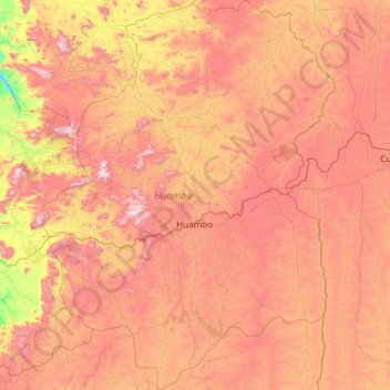
Name: Huambo Province topographic map, elevation, terrain.
Location: Huambo Province, Angola (-13.76667 14.79250 -11.43389 16.59743)
Average elevation: 1,601 m
Minimum elevation: 855 m
Maximum elevation: 2,546 m
The Central Plateau is well within the tropical zone, but altitude and the effect of the southwestern Antarctic current combine to produce a moderate climate. The annual variation of temperature is small, with maximum temperatures varying between 17 and 28 °C during much of the year. The average maximum is approximately 22 °C. During the winter months (May–July), temperatures may reach as low as 5 to 8 °C. Mean annual rainfall varies from 800 to 1600 mm, according to region. In the Central Plateau, seasonal rains begin with a few showers during September, increase during October and November, have a break of two to four weeks in December, January or February, and continue until the end of April. The heaviest rainfall is usually in November or December.
Other topographic maps
Click on a map to view its topography, its elevation and its terrain.
Luanda
Angola > Luanda Province > Municipality of Luanda
Luanda, Municipality of Luanda, Luanda Province, Angola
Average elevation: 44 m