
Thank you for supporting this site ❤️
Make a donation
Make a donation
Limburg topographic map
Click on the map to display elevation.
Thank you for supporting this site ❤️
Make a donation
Make a donation
About this map
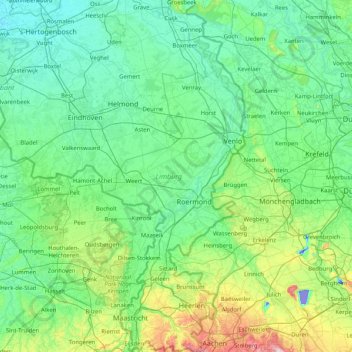
Name: Limburg topographic map, elevation, terrain.
Location: Limburg, Netherlands (50.75037 5.56605 51.77863 6.22677)
Average elevation: 49 m
Minimum elevation: -42 m
Maximum elevation: 375 m
Thank you for supporting this site ❤️
Make a donation
Make a donation
Other topographic maps
Click on a map to view its topography, its elevation and its terrain.
Thank you for supporting this site ❤️
Make a donation
Make a donation
Thank you for supporting this site ❤️
Make a donation
Make a donation