
Make a donation
Rincon topographic map
Click on the map to display elevation.
Make a donation
About this map
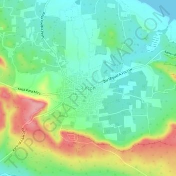
Name: Rincon topographic map, elevation, terrain.
Location: Rincon, Bonaire, Netherlands (12.21867 -68.34982 12.25867 -68.30982)
Average elevation: 40 m
Minimum elevation: 0 m
Maximum elevation: 119 m
Make a donation
Other topographic maps
Click on a map to view its topography, its elevation and its terrain.
Ridderkerk
Topographic map of the municipality of Ridderkerk
Average elevation: 1 m
Make a donation
Goirle
Dutch Topographic map of the municipality of Goirle, June 2015
Average elevation: 18 m
Make a donation
Apeldoorn
In 1689 William III became King of England, Scotland and Ireland and this elevation of his position and power brought an enlargement of Het Loo in its wake. Between 1691 and 1694 the colonnades which linked the corps de logis to the wings on either side were replaced by four pavilions. These pavilions…
Average elevation: 36 m
Make a donation
Make a donation
Make a donation
Make a donation
Make a donation
Make a donation
Boxtel
Dutch topographic map of the municipality of Boxtel, 2021
Average elevation: 8 m
Make a donation
Make a donation
Bonaire
While Bonaire has some hills and variations in altitude, Klein Bonaire's surface is quite level and just about two meters above sea level. Because Klein Bonaire is as yet undeveloped, the fringing reef system surrounding Klein Bonaire is pristine.
Average elevation: 1 m
Make a donation
Make a donation
Zoeterwoude
Dutch topographic map of Zoeterwoude, Sept. 2014. Click to enlarge.
Average elevation: -1 m
Make a donation
Make a donation
Make a donation
Heerlen
Heerlen's high elevation makes it one of the highest cities above sea level in the Netherlands.
Average elevation: 131 m
Make a donation
Make a donation
Make a donation
Make a donation