Independence County topographic map
Interactive map
Click on the map to display elevation.
Independence County topographic map, elevation, terrain
About this map
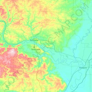
Name: Independence County topographic map, elevation, terrain.
Location: Independence County, Arkansas, United States (35.52579 -91.87139 35.94283 -91.19747)
Average elevation: 140 m
Minimum elevation: 60 m
Maximum elevation: 370 m
Other topographic maps
Click on a map to view its topography, its elevation and its terrain.
Bella Vista
United States > Arkansas > Benton County
The city of Bella Vista is located on the Springfield Plateau of the Ozark Mountains. Oak/hickory forests, along with valleys, creeks, and steep rises, characterize the city's topography. Bella Vista is located north of Bentonville and Rogers within the Northwest Arkansas region. The city has been experiencing…
Average elevation: 372 m
Fort Smith
United States > Arkansas > Sebastian County > Fort Smith
The United States acquired this territory and large areas west of the Mississippi River from France in the Louisiana Purchase (1803). Soon after, the government sent the Pike Expedition (1806) to explore the areas along the Arkansas River. The US founded Fort Smith in 1817 as a military post. It was named…
Average elevation: 140 m
Fayetteville
United States > Arkansas > Washington County
Fayetteville has a humid subtropical climate (Köppen Cfa). Fayetteville experiences all four seasons and does receive cold air masses from the north; however, some of the Arctic masses are blocked by the higher elevations of the Ozarks.
Average elevation: 401 m