
Village of Kingston topographic map
Interactive map
Click on the map to display elevation.
About this map
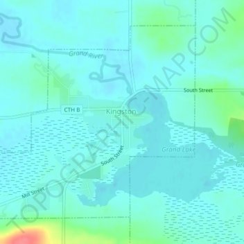
Name: Village of Kingston topographic map, elevation, terrain.
Average elevation: 247 m
Minimum elevation: 237 m
Maximum elevation: 301 m
Other topographic maps
Click on a map to view its topography, its elevation and its terrain.
Spring Grove
United States > Wisconsin > Green Lake County
Spring Grove, Town of Green Lake, Green Lake County, Wisconsin, 54941, United States
Average elevation: 260 m
Tuleta Hills
United States > Wisconsin > Green Lake County
Tuleta Hills, Town of Green Lake, Green Lake County, Wisconsin, 54941, United States
Average elevation: 255 m
Fairburn
United States > Wisconsin > Green Lake County
Fairburn, Town of Seneca, Green Lake County, Wisconsin, United States
Average elevation: 235 m
Sandstone Bluff
United States > Wisconsin > Green Lake County
Sandstone Bluff, Town of Green Lake, Green Lake County, Wisconsin, 54941, United States
Average elevation: 254 m
Green Lake Terrace
United States > Wisconsin > Green Lake County
Green Lake Terrace, Town of Princeton, Green Lake County, Wisconsin, United States
Average elevation: 246 m
Center House
United States > Wisconsin > Green Lake County
Center House, Town of Green Lake, Green Lake County, Wisconsin, United States
Average elevation: 290 m
Utley
United States > Wisconsin > Green Lake County
Utley, Town of Green Lake, Green Lake County, Wisconsin, 53931, United States
Average elevation: 291 m
Pleasant Point
United States > Wisconsin > Green Lake County
Pleasant Point, Town of Brooklyn, Green Lake County, Wisconsin, 54941, United States
Average elevation: 252 m
Indian Hills
United States > Wisconsin > Green Lake County
Indian Hills, Town of Green Lake, Green Lake County, Wisconsin, 54941, United States
Average elevation: 255 m
Greenwyck
United States > Wisconsin > Green Lake County
Greenwyck, Town of Green Lake, Green Lake County, Wisconsin, United States
Average elevation: 256 m
Village of Marquette
United States > Wisconsin > Green Lake County
Village of Marquette, Green Lake County, Wisconsin, 53947, United States
Average elevation: 242 m
Puckaway Lake
United States > Wisconsin > Green Lake County
Puckaway Lake, Town of Marquette, Green Lake County, Wisconsin, United States
Average elevation: 238 m
Town of Green Lake
United States > Wisconsin > Green Lake County
Town of Green Lake, Green Lake County, Wisconsin, 53946, United States
Average elevation: 285 m
Town of Brooklyn
United States > Wisconsin > Green Lake County
Town of Brooklyn, Green Lake County, Wisconsin, United States
Average elevation: 254 m
Markesan
United States > Wisconsin > Green Lake County
Markesan, Green Lake County, Wisconsin, United States
Average elevation: 282 m
Town of Manchester
United States > Wisconsin > Green Lake County
Town of Manchester, Green Lake County, Wisconsin, 53946, United States
Average elevation: 276 m
Dalton
United States > Wisconsin > Green Lake County
Dalton, Town of Kingston, Green Lake County, Wisconsin, 53926, United States
Average elevation: 258 m
City of Berlin
United States > Wisconsin > Green Lake County
City of Berlin, Green Lake County, Wisconsin, United States
Average elevation: 240 m
City of Green Lake
United States > Wisconsin > Green Lake County
City of Green Lake, Green Lake County, Wisconsin, 54941, United States
Average elevation: 250 m
Village of Princeton
United States > Wisconsin > Green Lake County
Village of Princeton, Green Lake County, Wisconsin, 54988, United States
Average elevation: 242 m