
Make a donation
Highland Lake topographic map
Click on the map to display elevation.
Make a donation
Highland Lake
Highland Lake is located in eastern Blount County at 33°53'3.376" North, 86°25'19.744" West (33.884271, -86.422151). The town consists of homes built around Highland Lake, a reservoir on the Blackburn Fork of the Little Warrior River. The lake, at an elevation of 895 feet (273 m) above sea level, is in a valley between Blount Mountain to the southeast and Straight Mountain to the northwest. The town is 7 miles (11 km) southwest of Oneonta, the county seat, along County Road 29.
Make a donation
About this map
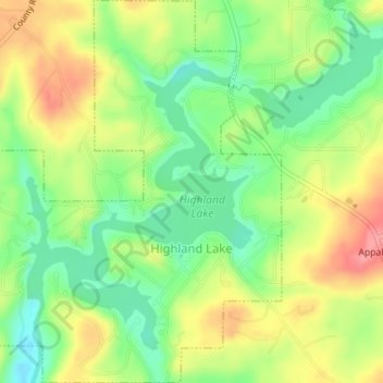
Name: Highland Lake topographic map, elevation, terrain.
Location: Highland Lake, Blount County, Alabama, United States (33.87485 -86.43779 33.90396 -86.41144)
Average elevation: 299 m
Minimum elevation: 257 m
Maximum elevation: 349 m
Make a donation
Other topographic maps
Click on a map to view its topography, its elevation and its terrain.
Make a donation
Make a donation
Make a donation