
Thank you for supporting this site ❤️
Make a donation
Make a donation
Brooksville topographic map
Click on the map to display elevation.
Thank you for supporting this site ❤️
Make a donation
Make a donation
About this map
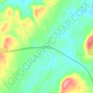
Name: Brooksville topographic map, elevation, terrain.
Location: Brooksville, Blount County, Alabama, United States (34.14204 -86.49554 34.18204 -86.45554)
Average elevation: 258 m
Minimum elevation: 214 m
Maximum elevation: 341 m
Thank you for supporting this site ❤️
Make a donation
Make a donation
Other topographic maps
Click on a map to view its topography, its elevation and its terrain.
Thank you for supporting this site ❤️
Make a donation
Make a donation
Highland Lake
United States > Alabama > Blount County
Highland Lake is located in eastern Blount County at 33°53'3.376" North, 86°25'19.744" West (33.884271, -86.422151). The town consists of homes built around Highland Lake, a reservoir on the Blackburn Fork of the Little Warrior River. The lake, at an elevation of 895 feet (273 m) above sea level, is in a…
Average elevation: 299 m
Thank you for supporting this site ❤️
Make a donation
Make a donation
Thank you for supporting this site ❤️
Make a donation
Make a donation