
Make a donation
Bromsgrove topographic map
Click on the map to display elevation.
Make a donation
About this map
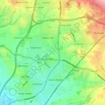
Name: Bromsgrove topographic map, elevation, terrain.
Location: Bromsgrove, Worcestershire, England, United Kingdom (52.31151 -2.08468 52.36600 -2.02139)
Average elevation: 119 m
Minimum elevation: 56 m
Maximum elevation: 233 m
Make a donation
Other topographic maps
Click on a map to view its topography, its elevation and its terrain.
Lickey Hills Country Park
United Kingdom > England > Worcestershire > Bromsgrove > Cofton Hackett CP
The visitor centre, which first opened in April 1990, contains an exhibition, leaflets and information on nature trails, guided walks and other activities organised by the Ranger Service. It also has a small café and gift shop. There are three car parks, one for the visitor centre, one by the golf club house…
Average elevation: 208 m
Drayton
United Kingdom > England > Worcestershire > Wyre Forest District > Drayton
Average elevation: 112 m
Make a donation