
Thank you for supporting this site ❤️
Make a donation
Make a donation
Wyndhamganj topographic map
Click on the map to display elevation.
Thank you for supporting this site ❤️
Make a donation
Make a donation
About this map
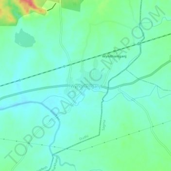
Name: Wyndhamganj topographic map, elevation, terrain.
Location: Wyndhamganj, Dudhi, Sonbhadra, Uttar Pradesh, India (24.23532 83.37393 24.27532 83.41393)
Average elevation: 250 m
Minimum elevation: 233 m
Maximum elevation: 305 m
Thank you for supporting this site ❤️
Make a donation
Make a donation
Other topographic maps
Click on a map to view its topography, its elevation and its terrain.