
Thank you for supporting this site ❤️
Make a donation
Make a donation
Sandwich topographic map
Click on the map to display elevation.
Thank you for supporting this site ❤️
Make a donation
Make a donation
About this map
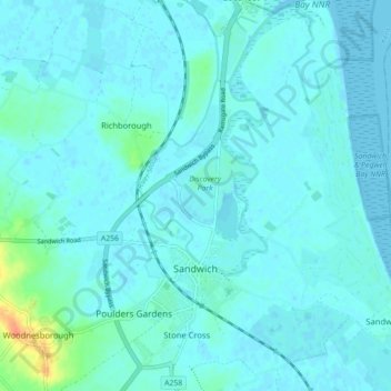
Name: Sandwich topographic map, elevation, terrain.
Location: Sandwich, Dover, Kent, England, United Kingdom (51.25793 1.32070 51.31302 1.36964)
Average elevation: 5 m
Minimum elevation: -1 m
Maximum elevation: 40 m
Thank you for supporting this site ❤️
Make a donation
Make a donation
Other topographic maps
Click on a map to view its topography, its elevation and its terrain.
Nelson Park
United Kingdom > England > Kent > Dover > St. Margaret's at Cliffe
Average elevation: 69 m
Thank you for supporting this site ❤️
Make a donation
Make a donation
White Cliffs of Dover
United Kingdom > England > Kent > Dover > St. Margaret's at Cliffe
Average elevation: 49 m
Thank you for supporting this site ❤️
Make a donation
Make a donation
Thank you for supporting this site ❤️
Make a donation
Make a donation
Thank you for supporting this site ❤️
Make a donation
Make a donation
Thank you for supporting this site ❤️
Make a donation
Make a donation
Park Gate
United Kingdom > England > Kent > Folkestone and Hythe District > Elham
Average elevation: 130 m