
Angul District topographic map
Interactive map
Click on the map to display elevation.
About this map
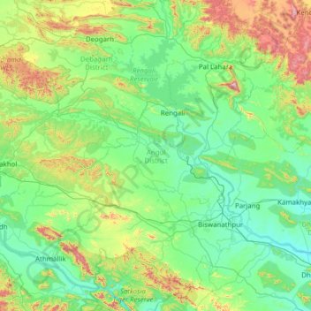
Name: Angul District topographic map, elevation, terrain.
Location: Angul District, Odisha, India (20.52806 84.26205 21.68017 85.39269)
Average elevation: 234 m
Minimum elevation: 37 m
Maximum elevation: 1,161 m
Angul is located in the centre of the state of Odisha and lies between the latitudes of 20°31′N and 21°40′N and longitudes of 84°15′E and 85°23′E. The altitude is between 564 and 1,187 metres (1,850 and 3,894 ft). The district has an area of 6,232 km2 (2,406 sq mi). It is bounded by Dhenkanal and Cuttack district in the east, Deogarh, Kendujhar and Sundargarh district in north, Sambalpur and Sonepur in west and Boudh and Nayagarh in the south side. The district is abundant with natural resources. Angul, The district headquarters is about 150 kilometres (93 mi) from the state capital Bhubaneswar.
Other topographic maps
Click on a map to view its topography, its elevation and its terrain.
Purunakatak
India > Odisha > Puruna Katak
Purunakatak, Puruna Katak, Boudh District, Odisha, 762013, India
Average elevation: 143 m
Cuttack
India > Odisha > Cuttack (M.Corp.) P.S
Cuttack, Cuttack (M.Corp.) P.S, Cuttack, Odisha, 753001, India
Average elevation: 34 m
Ward 43
India > Odisha > Bhubaneswar (M.Corp.) > Bhubaneswar Municipal Corporation
Ward 43, South East Zone, Bhubaneswar Municipal Corporation, Bhubaneswar (M.Corp.), Khordha District, Odisha, India
Average elevation: 28 m
Barabati
India > Odisha > Dharmasala
Barabati, Dharmasala, Jajpur District, Odisha, 755008, India
Average elevation: 17 m
Subarnapur
Subarnapur, Sonapur, Subarnapur District, Odisha, 767017, India
Average elevation: 112 m
Rushikulya
India > Odisha > Purusottampur
Rushikulya, Purusottampur, Ganjam District, Odisha, India
Average elevation: 32 m
Vamsadhara
India > Odisha > Gudari > Gudari
Vamsadhara, Gudari, Rayagada District, Odisha, 765026, India
Average elevation: 304 m
Brahmapur (M.Corp.)
Brahmapur (M.Corp.), Ganjam District, Odisha, India
Average elevation: 22 m
Ward 44
India > Odisha > Bhubaneswar (M.Corp.) > Bhubaneswar Municipal Corporation
Ward 44, South East Zone, Bhubaneswar Municipal Corporation, Bhubaneswar (M.Corp.), Khordha District, Odisha, India
Average elevation: 21 m
Kusumi
India > Odisha > Mahulpalli
Kusumi, Mahulpalli, Sambalpur District, Odisha, India
Average elevation: 270 m
Boudh
India > Odisha > Baudh Sadar
Boudh, Baudh Sadar, Boudh District, Odisha, 762014, India
Average elevation: 93 m
Kendujhargarh
India > Odisha > Kendujhar Town
Kendujhargarh, Kendujhar Town, Kendujhar District, Odisha, 758001, India
Average elevation: 481 m
Paradeep Lock
Paradeep Lock, Jagatsinghapur District, Odisha, India
Average elevation: 3 m
Biramitrapur
India > Odisha > Biramitrapur
Biramitrapur, Sundargarh District, Odisha, 770033, India
Average elevation: 285 m
Brahmani River
Brahmani River, Rajnagar, Kendrapara District, Odisha, India
Average elevation: 3 m
Narayanpatana
Narayanpatana, Koraput District, Odisha, 764014, India
Average elevation: 677 m
KAIPADAR
India > Odisha > Khordha Sadar
KAIPADAR, Khordha Sadar, Khordha District, Odisha, 752056, India
Average elevation: 62 m